|
|
|
| Missing In Action (MIA) | Prisoners Of War (POW) | Unexploded Ordnance (UXO) |
| Chronology | Locations | Aircraft | Ships | Submit Info | How You Can Help | Donate |
|
 Justin Taylan 2003 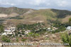 Justin Taylan 2007 |
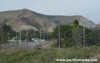
Location Lat 9° 28' 4S Long 147° 8' 54E Burns Peak is a large hill in the Port Moresby area of southern New Guinea. To the southwest is Hanabada, Kaevaga, Konedobu and beyond to the south is Port Moresby. To the northeast is June Valley (Goon Gully). Prewar and during the Pacific War part of Central District in the Territory of Papua. Today located in National Capital District (NCD) in Papua New Guinea (PNG). Wartime History By 1943, a fuel jetty and pipeline was built from Hanabada into Fairfax Harbor allowing fuel from ships to be piped to the northeast over the hills to the east of Burns Peak into June Valley (Goon Gully) then down to the northern end of 5 Mile Drone (Ward Drome). Today Atop the summit of Burns Peak are antennas. In the late 1990's a road cut was made into the hill to allow for the highway. B-24J Liberator Serial Number 42-100205 Pilot Waurie crashed March 12, 1944 into a valley atop Burns Peak Contribute
Information Last Updated
|
Map 1943 |
| Discussion Forum | Daily Updates | Reviews | Museums | Interviews & Oral Histories |
|