|
|
|
| Missing In Action (MIA) | Prisoners Of War (POW) | Unexploded Ordnance (UXO) |
| Chronology | Locations | Aircraft | Ships | Submit Info | How You Can Help | Donate |
|
 USAAF Nov 18, 1943 |
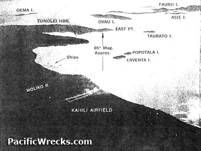
Location Lat 6°48'4"S Long 155°49'33"E Erventa Island is a small island bordering Erventa Harbor (Buin Harbor) off southern Bougainville Island, in the Autonomous Region of Bougainville (Bougainville Province) in Papua New Guinea (PNG). to the west are Kahili and Buin. To the east is Tonolei Harbor. Nearby is Popotala Island. Today, located near the international border between Papua New Guinea and the Solomon Islands. Wartime History During early 1942, occupied by the Japanese. During 1944 bombed by American aircraft. Occupied by the Japanese until the official surrender of Japan in September 1945. Allied missions against Erventa Island June 30, 1944–July 1, 1944 Contribute
Information Last Updated
|
Map Mapcarta |
| Discussion Forum | Daily Updates | Reviews | Museums | Interviews & Oral Histories |
|