|
|
|
| Missing In Action (MIA) | Prisoners Of War (POW) | Unexploded Ordnance (UXO) |
| Chronology | Locations | Aircraft | Ships | Submit Info | How You Can Help | Donate |
|
  Bottomley Oct 3, 1942 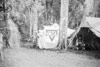 Watson Sept 23, 1942 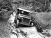 Nicholson April 12, 1944 |
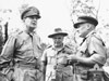
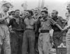
Location Owers' Corner is located in Central Province in Papua New Guinea (PNG). At this location, the road becomes the foot path that connects to the start of the Kokoda Trail across the the Owen Stanley Range. To the located south is McDonald's Corner and Sogeri. Sometimes incorrectly spelled "Owens Corner" or "Owers Corner". Wartime History Nicknamed "Owers' Corner" in honor of Lt. Noel "Jerry" Owers who advanced to this location with a survey party seeking an alternative route to Ilolo to transport supplies to the Australian Army troops in the Owen Stanley Range. In late September 1942, Australian Army 25 Pounder guns of B Troop, 53rd Battery, 14th Field Regiment were emplaced at this location. On September 23, 1942 these guns began firing at Japanese forces occupying Ioribaiwa. During late September, the Australian Army 16th Brigade began advancing from this location northward towards Kokoda. In late September to early October 1942, a tower was constructed using bush materials with a flying fox to transport materials and equipment to the beginning of the Kokoda Track. On October 3, 1942 a group of senior staff including U.S. Army General Douglas MacArthur, General Herring and General Kenney with Australian Army General Blamey and Minister for the Army Mr. F. M. Forde visit Owers' Corner. At Ower's Corner, the group interacts with Australian Army personnel and MacArthur told Brigadier J. E. Lloyd, 16th Brigade C.O., "Lloyd, by some act of God, your Brigade has been chosen for this job. The eyes of the Western world are upon you. I have every confidence in you and your men, good luck, don't stop." After the battle, the area continued to be used as a military camp area. During late 1943 a carrier camp for natives carrying cargo across the Kokoda Trail was established at this location. Today Owers' Corner is the starting point for trekkers walking the Kokoda Trail northward, or the end point for those walking southward. Owers' Corner Memorial There is a memorial marker here and small memorial park. References Field Guide to the Kokoda Track pages 141 (map), 147-151 (Ower's Corner) Hell's Battlefield (2012) by Phil Bradley pages 60, 69, 92-93, 499 (index) WW2 Nominal Roll - Noel Owers, NGX369 Contribute
Information Last Updated
|
Map 1999 Map Fallingrain Photo Archive |
| Discussion Forum | Daily Updates | Reviews | Museums | Interviews & Oral Histories |
|