|
|
|
| Missing In Action (MIA) | Prisoners Of War (POW) | Unexploded Ordnance (UXO) |
| Chronology | Locations | Aircraft | Ships | Submit Info | How You Can Help | Donate |
|
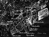 USAAF April 29, 1945 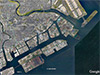 Google Earth Jan 9, 2018 |
Location Lat 35° 31′ 0″ N Long 139° 42′ 0″ E Kawasaki is located in Kanagawa Prefecture in the Keihin Region inside the Kantō Region on Honshū in Japan. Also known as Kawasaki City. To the northeast is Tama River (Tama-gawa) and beyond Tokyo. To the southwest is Tsurumi River (Tsurumi-gawa) and beyond Yokohama. Borders Tokyo Bay to the east and south. Wartime History Prewar and during the Pacific War, Kawasaki was an industrial center with oil refineries, power plants and heavy industry including Asano Iron Works, Japan Steel Tube Company, Tokyo Electric Power Station (Tsurumi Plant) Kawasaki Electric Power Plant, Mitsubishi Oil Refinery, Tsurumi Steel and Shipbuilding Company, Hayama Petroleum Refinery, Asaishi Petroleum Company, Shibaura Engineering Works, Fuji Electric Works, Showa Fertilizer, Tokyo Gas Company (Tsurumi Branch), Tokyo-Shibaura Electric Co., Factory No. 2 (Yanagi Plant), Tokyo Steam Power Plant, Tokyo-Shibaura Electric Company, Factory No. 1 (Horikawa Plant), Ebara Manufacturing Company (Kamata Plant), Army Oil Storage and Tokyo-Shibaura Electric Company, Factory No. 3 (Komukai Plant). During the Pacific War, Mitsubishi Oil Refinery and Hayama Petroleum Center were key oil refineries in Kawasaki. Starting in early April 1945 attacked by B-29 Superfortress heavy bombers until the end of the Pacific War. The bombing raids destroyed much of the industrial infrastructure and urban area. American missions against Kawasaki April 3, 1945–August 1, 1945 Today Kawasaki is the ninth most populated city in Japan and one of the main cities in the Greater Tokyo area and part of the Keihin industrial area. Contribute
Information Last Updated
|
Map 1945 Map Fallingrain Photo Archive |
| Discussion Forum | Daily Updates | Reviews | Museums | Interviews & Oral Histories |
|