|
|
|
|
| Missing In Action (MIA) | Prisoners Of War (POW) | Unexploded Ordnance (UXO) |
| Chronology | Locations | Aircraft | Ships | Submit Info | How You Can Help | Donate |
|
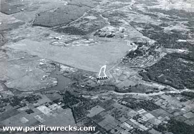  Dutch c1950 |
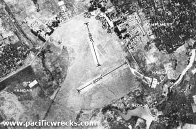
Location Lat 6° 31' 53S Long 107° 39' 32E Kalidjati Airfield is located at an elevation of 361' above sea level to the west of Kalijati in western Java. Also spelled Kalidjati, Kalijati, Karichagi or Kalijaga. Prewar and during the Pacific War part of the Netherlands East Indies (NEI). Today located in West Java Province (Jawa Barat) in Indonesia. Construction Built by the Dutch prewar. Kalidjati had two perpendicular runways, one running roughly north to south and the other southwest to northeast. Wartime History This airfield was defended by a mixed force of Royal Dutch Netherlands East Indies Army, 49 Battery of the 48 Light Antiaircraft Regiment R A, a detachment of RAF acting as ground troops, and a company of light tanks of the 3rd Kings Own Hussars, RAC. During the night prior to the Japanese attack, Dutch forces were withdrawn without notice from the airfield. On March 1, 1942 the remaining defenders unexpectedly discovered Japanese armored vehicles advancing onto the edge of the airfield. They hastily assembled to defend the area with 49 Battery loosing over 50 men. The survivors were captured by the Japanese. Later that week when Allied commanders met with the Japanese in connection with the capitulation negotiations, the Japanese commanders congratulated the British for their courageous defense of Kalijati Airfield. After the surrender, occupied by the Japanese for the duration of the Pacific War. Known to the Japanese as "Karichagi", a phonetic pronunciation of "Kalidjati". Used by the Japanese Army Air Force (JAAF) as a forward airfield for bombing missions against Darwin. Japanese units based at Kalijati 7th Sentai (Ki-49) Postwar Remained in use as Kalijati Air Base used by the Dutch. During 1950 the runways measured 2,000' x 1,600'. Today Still in use today as Kalijati Airport. Airport codes: ICAO: WIIK. References Index to Air Bases - Research Report No. 85, I.G. No 9185 - July 30, 1944 Thank to Dick Kesseling for additional information Contribute
Information Last Updated
|
Fallingrain View in Google Earth |
| Discussion Forum | Daily Updates | Reviews | Museums | Interviews & Oral Histories |
|