|
|
|
| Missing In Action (MIA) | Prisoners Of War (POW) | Unexploded Ordnance (UXO) |
| Chronology | Locations | Aircraft | Ships | Submit Info | How You Can Help | Donate |
|
 Lucas October 1914  AWM May 1941  USAAF Dec 19, 1943 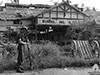 AWM April 24, 1944 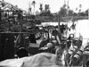 AWM April 30, 1944 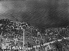 AWM October 1945 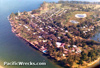 David Pennefather 1980 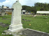 Walt Deas 2001 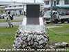 Justin Taylan, 2004 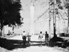 AWM 1959  Justin Taylan 1993 |
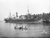
Location Lat 5° 13' 0S Long 145° 48' 0E Madang is located on the north coast of New Guinea. Also known as "Madang Town". Borders Madang Harbor and beyond to the east and Astrolabe Bay to the southeast. The North Coast Road connects northward to Alexishafen and southward towards Bil Bil (Bili Bili) and beyond. Prewar and during the Pacific War located in the Territory of New Guinea. Today, Madang is the provincial capital of Madang Province in Papua New Guinea (PNG). Prewar During 1884, Madang was founded by the Germans as "Friedrich Wilhelmshafen" or "Friedrich-Wilhelmshafen". The Germans established coconut palm plantations harvesting copra and Catholic and Lutheran missions. They administered there area until the start of World War I. World War I On September 24, 1914, the Australian Naval and Military Expeditionary Force (AN&MEF) arrived at Madang Harbor and occupied Madang without any opposition. SMS Cormoran escaped undetected. The SS Matunga was the first commercial vessel to arrive at Madang docked at Madang wharf during October 1914. Occupied by Australian forces for the remainder of the war until 1921 when Australia received a mandate from the League of Nations to govern the area. A wireless station was established, Madang AWA radio station (call sign VIV). World War II On December 13, 1941 all European women and children were ordered to evacuate from Madang by ship or plane via Port Moresby then to the safety of Australia. The New Guinea Volunteer Rifles (NGVR) under the command of Sgt Gordon Russell were tasked with defending Madang with a small contingent at Madang Airfield. On January 21, 1942 the first Japanese air raid hit Madang destroying a cargo shed on the wharf there and two big stores full of copra that burned for two weeks and caused many locals to flee and bomb Madang Airfield. Afterwards, the NGVR set up a wireless station at Usino and were instructed to commandeer small ships and fuel. During an operation commanded by Assistant District Officer (ADO) Keith McCarthy with Patrol Officer G. C. "Blue" Harris, a vessel from the Divine Word Mission plus two Lutheran ships Bavaria and Umboi were used to evacuate other civilians from the Sepik District. Meanwhile, Edith arrived with Australian Army soldiers from the 2/1 Independent Company that had evacuated Manus with District Officer (DO) Don Vertigan. The remaining civilians and those rescued made an organized withdrawal from Madang, walking inland to Amele, crossed the Gogol River to Usino then down the Ramu Valley to Kainantu. By early 1942, only a small NGVR force defended Madang that was unable to prevent the town from being vandalized and pillaged as law and order broke down. Japanese missions against Madang January 21, 1942 The Japanese plans to occupy Madang were delayed due to the changing situation on Guadalcanal. Finally, the Japanese Army 21st Infantry Regiment, 3rd Battalion and 42nd Infantry Regiment, 3nd Battalion commanded by Lt. Col. Hanawa embarked on several ships that departed Rabaul on December 16, 1942 bound for Madang On December 18, 1942 during the night, the Japanese force entered Madang Harbor and the Japanese Army lands unopposed at Madang. On December 23, 1942 in the early morning hours, Japanese Army soldiers embark on barges then land unopposed at Alexishafen and Bogadjim occupying both without opposition. Immediately, the Japanese Army developed Madang into a base area and attempted to build a road southward to Bogadjim. On April 19, 1943 the Imperial Japanese Army (IJA) 18th Army commander Lt. General Hatazo Adachi moved his headquarters from Wewak to Madang. Also, Japanese Army 20th Division and 41st Division troops were stationed at Madang. Starting in December 1942, Allied aircraft targeted Madang that destroyed most of the town. After the recapture of Lae and battle at Shaggy Ridge Australian Army 5th Division troops advanced towards Madang, which was bypassed by April 22, 1944 by the U.S. landings further to the west at Aitape and Hollandia. Allied missions against Madang December 13, 1942–April 26, 1944 On April 24, 1944 Australian Army soldiers entered Madang, encountering only a Japanese rear guard with a single horse drawn artillery piece and liberated the town then advanced on the North Coast Road towards Alexishafen. Madang was heavily damaged by Allied bombing and strafing and most buildings including the Hotel Madang were in ruins. During the Allied occupation, Madang was rebuilt and developed into an Australian Army headquarters and base area for the remainder of the Pacific War. Today Today, Madang is an idyllic coastal town and a popular tourist destination. On September 24, 2014 around 9:30am a World War II era bomb exploded in Madang Town's business district near Brian Bell outlet and an Asian supermarket opposite the police station. Madang’s Acting Provincial Police Commander Chief Inspector Benae Neneo stated the explosion was triggered by what is believed to be a war time bomb. Reference: Post Courier "WWII bomb explosion rocks Madang Town" September 26, 2014 page 8. Madang Airfield Prewar airfield used by the Japanese and Allies during the war, still in use today. German Missionary Cemetery Prewar German missionary cemetery located in the center of Madang town. Some of the grave stones are scared by bullets from the wartime fighting in the area. 5th Australian Division Memorial Memorial in the center of Madang town. The plaque reads: "A platoon of the 50th battalion and a patrol of the 51/60th Battalion defeated a small Japanese rearguard and entered Madang on the 24th April 1944." Coastwatchers Memorial Lighthouse Located at Kalibobo Point south of Madang. The Coastwatchers memorial is a 30m tall white memorial tower visible roughly 25km out to sea. During June 1953 a committee was formed in Melbourne to raise funds for a memorial to the 28 Coastwatchers that died in New Guinea. A fundraising committee was created in Madang and many Madang Chinese donated to the memorial and the Madang RSL. By January 1954 the site for the monument was selected on the southern entrance to Madang Harbor at what was to be called the Coastwatchers Memorial Lighthouse. Dedicated on August 15, 1959. Its a reminder to the men who stayed behind the lines during the war to report on Japanese troop and ship movements. The coastal road is one of the more pleasant in Madang, fringed by palm trees and poincianas with fine views of across Astrolabe Bay towards the Rai coast. References Madang page 183 75mm Anti-Aircraft Gun Type 88 (1928) Emplaced on Coronation Drive south of the Coastwatchers memorial bordering Astrolabe Bay References Madang by Jame Sinclair 135-150 Contribute
Information Last Updated
|
Map Sept 28, 1943 Map 1944 Map Fallingrain Photo Archive |
| Discussion Forum | Daily Updates | Reviews | Museums | Interviews & Oral Histories |
|