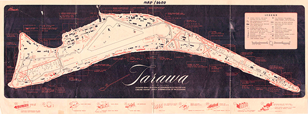
Map of Tarawa (Betio) showing Japanese defenses
The subtitle reads: Tarawa Betio Island
showing enemy situation as interpreted by D-2 section and checking against JICPOA interpretation of photographs. At the center is Tarawa Airfield. The northern edge shows the boat basin and piers bordering Tarawa Lagoon. Dots indicated wooded areas with coconut palm trees. Solid lines indicate roads and solid rectangles are buildings. Circled letters A-J indicate various types of defensive positions including barricades, trenches, rifle pits, barbed wire, log barricades, barriers, embankments with barricades and coral block seawalls. Different types of weapons are indicated by symbols indicating weapon type and caliber.
Credit: USMC Date: 1943
Map
High Resolution Version
Acquire This Image |
Contribute
Information
Do you have photos or additional information?
Make A Donation | Previous Page | Pacific Wrecks |