|
|
|
| Missing In Action (MIA) | Prisoners Of War (POW) | Unexploded Ordnance (UXO) |
| Chronology | Locations | Aircraft | Ships | Submit Info | How You Can Help | Donate |
|
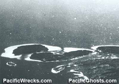 USN October 11, 1943    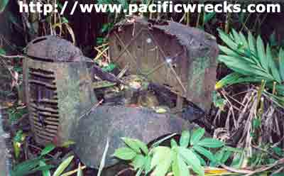 Justin Taylan 2003 |
Location Lat 7° 5' 29S Long 155° 51' 57E Nila is located on the north coast of Poporang Island in the Shortland Island Group (Shortland Islands) in Western Province in the Solomon Islands. Borders Tuha Channel to the north and Shortland Harbor to the northeast. Prewar In 1899, the Catholic Church established a mission at Nila and built a church and hospital at this location. Also, Nila Plantation was established at this location planted with coconut palms for copra and spanned the northeastern portion of the island. Buildings for copra storage, a hospital and church were located at Nila. Also, there was a small Chinese community at Nila. At the start of the Pacific War, the British government ordered all European inhabitants to be evacuated by boat from the Solomon Islands. Remaining behind were Chinese who were not evacuated by the government. The Catholic Priests at Nila declined to evacuate in favor of staying with their congregations and (falsely) believing they would be treated as non-combatants. During 1942, three Catholic priests remained at Nila: Father Maurice Bock (French), Father Binos (French) and Father George Lepping (American). Wartime History On March 30, 1942 at 2:00am, Japanese forces occupied the area without resistance. The Japanese captured the three Catholic priests and later transported them to Rabaul where they were detained at Vunapope for the remainder of the Pacific War. During the Japanese occupation, Nila and Poporang Island were developed into a base area to support Shortland Harbor anchorage and Shortland Harbor Seaplane Base. The area was defended with bunkers, fortifications, shore guns, anti-aircraft guns, searchlights and radar. Targeted by American bombers and fighters and bombarded by U.S. Navy warships, the area was heavily bombed and shelled during 1943. After the November 1, 1943 U.S. landing at Torokina the northern Solomon Islands including Nila was bypassed and left to "wither on a vine" and continued to be a target until October 1944. American missions against Poporang March 28, 1943 - October 1, 1944 Until the end of the Pacific War and official surrender of Japan, Nila and Poporang Island remained occupied by the Japanese until September 1945. Postwar After the war, the Catholic church was rebuilt at Nila. The alter is made from the base of a Japanese searchlight and the mission used abandoned Japanese equipment and infrastructure. Postwar in th 1950s, the priest based at Nila was Father Wally Finkleton (Australian). Today Nila is the largest settlement on Poporang Island. E13A1 Jake Manufacture Number 5155 Salvaged from shallow water in 1968 abandoned at Nila. Seaplane Ramp and Servicing Area On the shore at Nila, overgrown by bush is a servicing area for F1M2 Pete seaplanes. The fuselages of several Pete seaplanes were abandoned at this location. In November 2007, one of these fuselages was removed by Craig Turner / Solomon Islands National Museum Project on November 8, 2007 aboard transport "Tina". F1M2 Pete Manufacture Number 2265 Tail PO-16 Abandoned in a boneyard area. F1M2 Pete Constructors Number 1250 Tail L-215 Abandoned in a boneyard area. Salvaged by Craig Turner / SI Museum Project November 8, 2007 A path has been built over the swamp made from the wings of F1M2 Pete biplanes, presumably from the nearby Dump area. Chris Cowx adds: "I actually wiped away the mud and you could see the meatball insignia on the wings. Nearby is a collection of Japanese beer and sake bottles." Generator Bunker Blockhouse Nila was powered by the original generator used by the Japanese during the war. The lights which used to illuminate the base still operate when the generator is turned over, and this was in the late 1970's. Fortifications The area is zigzagged with trenches, tunnels, cement bunkers and the foundations of wooden buildings. On higher ground is located an anti- aircraft complex comprising several antiaircraft and coastal guns. Japanese Truck Located next to the Japanese built freshwater well, that still flows today. The cab section only of this truck. The engine, radiator, steering wheel and instruments have all been salvaged or otherwise removed. Search Light A medium sized searchlight, with intact shutters. It has been broken since the early 1970s and is thrown from its U shaped mount and lying in an earthen bunker area. Type 3 (1914) 76.2mm Anti-Aircraft Gun (No 1) This gun has shrapnel damage on the barrel and is facing at a slightly elevated angle. Type 3 (1914) 76.2mm Anti-Aircraft Gun (No 2) This gun has shrapnel damage on the barrel and is facing at a slightly elevated angle. Type 3 (1914) 76.2mm Anti-Aircraft Gun (No 3) This gun is broken into several components, and mostly buried in its emplacement. The barrel is separated laying to the side, and gun buried near the base. Type 3 (1914) 140mm Naval Gun (No 1) Located on the eastern portion of the island, facing Shortland Island. Gun turret with shield. A box of ammunition is lying nearby, and a dud shell behind the gun. The breech is removed and missing. Type 3 (1914) 140mm Naval Gun (No 2) Gun turret with shield. One of the gun's view ports in the shield is in the closed position. One of the recoil springs is lying to the side. Type 2, Mark 1 Model 2 Radar (No 1) Japanese Navy trailer mounted radar. Today, the radar still rotates 360 degrees. Type 2, Mark 1 Model 2 Radar (No 2) Japanese Navy trailer mounted radar with 100-120km search range. Interstate TDR Attack Drone Crashed October 1, 1944 References Shortland Islands Target Study December 1942 Solomon Islands Government Topographic Map 1:50,000 "Nuhu, Solomon Islands 0715504 X715 Edition 1-SI50K" information as of 2003, printed 2007 Contribute
Information Last Updated
|
Map April 11, 1943 Map Fallingrain |
| Discussion Forum | Daily Updates | Reviews | Museums | Interviews & Oral Histories |
|