|
|
|
| Missing In Action (MIA) | Prisoners Of War (POW) | Unexploded Ordnance (UXO) |
| Chronology | Locations | Aircraft | Ships | Submit Info | How You Can Help | Donate |
|
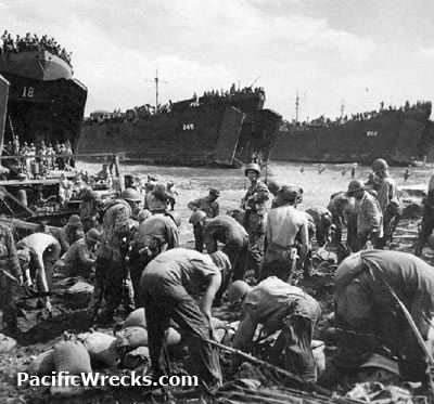  US Army Oct 20, 1944 |
Location Leyte Island is located in the Eastern Visayas (Region VIII) of the Philippines. Also known as simply Leyte. The island is divided into two provinces: Leyte Province (Northern Leyte Province) and Southern Leyte Province. Borders Samar Island to the northeast and Mindanao Island to the south, and San Pedro Bay and Leyte Gulf to the east and the Surigao Strait to the southeast. To the west is the Camotes Sea and Camotes Islands. Wartime History During 1942, occupied by the Japanese during their occupation of the Philippines. During the occupation, Filipino guerrilla leader Ruperto Kawgleon organized a force that was effective and part of the reason General MacArthur planned to liberate Leyte as first location liberated in the Philippines. On October 20, 1944 the U.S. Navy (USN) 7th Fleet lands the U.S. Army on eastern Leyte including the X Corps at Tacloban plus the XXIV Corps landing at Dulag. The Battle of Lyete Gulf between October 23, 1944 until October 26, 1944 results in the defeat of the Japanese Navy by the U.S. Navy during three battles. During the combat on and around Leyte, intense land, sea and air battles took place in the vicinity. Leyte was the first island in the Philippine archipelago to liberated by American forces. Leyte Island includes seven airfields, six built by the Japanese and one by American forces. Leyte Province (Northern Leyte Province) Locations Leyte Gulf located to the east of Leyte. San Pedro Bay located at the northwest end of Leyte Gulf bordering eastern Leyte. Tacloban (Tacloban City) provincial capital of Leyte Province includes Tacloban Airfield. Palo (Polo) located on the east coast includes the U.S. Army landing location Red Beach and MacArthur Landing Tanauan located outside Tacloban includes Tanauan Airfield. Tarragona (Tarraguna, Tarraguna, McArthur, MacArthur) located on the eastern coast of Leyte. Dulag located on the eastern coast of Leyte site of U.S. Army landing and Dulag Airfield. San Pablo located inland from the east coast of Leyte includes San Pablo Airfield. Burouen (Burauen) located inland from the eastern coast of Bayug. Buri located inland from the eastern coast of Leyte includes Buri Airfield. Ormoc located on the west coast of Leyte borders Ormoc Bay. Ormoc Bay located on the west coast of Leyte. Palompon (Palompan) located on the west coast of Leyte. Pinamopoan located on the northwest coast of Leyte. Southern Leyte Province Locations Maasin (Maasin City) provincial capital located at the southwest of Leyte. Cabugan Grande Island one of the twin islands off the southeast of Leyte. Leyte Province Airfields Bayug Airfield (Burouen, Burauen) located near Burouen (Burauen) inland from eastern Leyte Buri Airfield (Buro) located near Buri in eastern Leyte built by the Japanese and used by U.S. Dulag Airfield located at Dulag on eastern Leyte built by the Japanese and used by U.S. Ormoc Airfield located near Ormoc used by the Japanese. San Pablo Airfield located at San Pablo on eastern Leyte built by the Japanese and used by U.S. Tacloban Airfield (Daniel Z. Romualdez Airport) located at Tacloban at the northeast of Leyte. Battle of Baluarte Marker Located at Baluarte, Bgy. Minuhang Barugo. Site of the historic battle between Filipino guerrillas and Japanese Imperial Forces at dawn of August 24, 1944. Significant because there were no Filipino casualties while all the Japanese except one were killed in the encounter. The 3.5m square concrete memorial has three stairs with the top had three rifles crowned by a helmet fenced by silver painted chains; on one side are three flagpoles shaped like bayonets. Buga-Buga Hills The Buga-Buga Hills are located in the Villaba Mountains on Leyte Island. During late 1944, this area was defended by the Japanese Army under the command of General Suzuki. Attacked by U.S. Army troops, thousands of Japanese were killed defending the area and hundreds of Americans were killed. This area is frequently visited by Japanese memorial tour groups and bone hunting expeditions. Breakneck Ridge (Hill 1525) This feature was designated by the U.S. Army as Hill 1525 located to the west of west of Pinamopoan in the north of Leyte near Carigara Bay. Also nickamed Breakneck Ridge. During late 1944, defended by the Japanese Army 1st Division. Over an eight day period, Hill 1525 was assaulted by U.S. Army 32nd Infantry Division and resulted in 2,800 KIA and 9,500 WIA. References U.S. Army in World War II - Leyte: The Return to the Philippines Chapter XII The Mountain Barrier: Part One pages 210-220 Contribute
Information Last Updated
|
Map Oct 20, 1944 Map Fallingrain |
| Discussion Forum | Daily Updates | Reviews | Museums | Interviews & Oral Histories |
|