|
|
|
|
| Missing In Action (MIA) | Prisoners Of War (POW) | Unexploded Ordnance (UXO) |
| Chronology | Locations | Aircraft | Ships | Submit Info | How You Can Help | Donate |
|
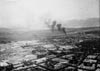 USN March 28, 1945 |
Location Lat 16° 2' 38N 108° 11' 58E Da Nang Airfield was located at Lat 16° 4' 0" N Long 108° 13' 0" E Da Nang Airfield (Tourane) is located at an elevation of 33' above sea level near Da Nang (Tourane) in Vietnam. During the French colonial era, known as Tourane or Turon in French Indochina (Indo-China). Still in use today known as Danang Airport. Construction Built prewar by the French colonial administration as a civilian airport, known as Tourane Airfield. Wartime History During 1941, occupied by the Japanese for the duration of the Pacific War. Japanese units based at Tourane (Da Nang) 901 Kokutai (A6M Zero detachment) early 1945 - April 1945 Korea American missions against Tourane (Da Nang) February 26, 1945–August 1, 1945 Vietnam War During the Vietnam War, Da Nang was one of the primary U.S. Air Force (USAF) bases in Vietnam. Today Still in use today as Da Nang International Airport (Danang Airport) as a civil and military airport with two runways. The first is oriented 35L/17R measures 10,000' x 148' surfaced with asphalt. The second is oriented 35R/17L measures 10,000' x 148' surfaced with asphalt. Airport Codes: ICAO: VVDN IATA: DAD. Today, it is the third highest traffic airport in the nation. References Danang International Airport offical website Contribute
Information Last Updated
|
Map Fallingrain Map Mapcarta Photo Archive |
| Discussion Forum | Daily Updates | Reviews | Museums | Interviews & Oral Histories |
|