|
|
|
|
| Missing In Action (MIA) | Prisoners Of War (POW) | Unexploded Ordnance (UXO) |
| Chronology | Locations | Aircraft | Ships | Submit Info | How You Can Help | Donate |
|
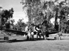 VF-17 c1944  RNZAF c1945  David Paulley 1982  H Sakaguchi 2003 |
Location Lat 6°12'28.48"S Long 155° 3'27.55"E Piva South Airfield is located at Piva on Bougainville. Located roughly 2.5 miles north-northeast of Cape Torokina. Also known as "Piva Yoke", "Yoke Airfield", "Piva 2" or simply "Fighter". Construction Piva South Airfield was one of two parallel runways built by the U.S. the single runway is oriented roughly east to west. Completed by December 30, 1943. At its height, Piva South (Fighter Strip) extended 6,000' x 150', with marson matting (PSP) on volcanic sand for 4,400' of the runway. Taxiways connected to Piva North Airfield (Piva Uncle, Piva No 1). Wartime History Piva South Airfield was used primarily as a fighter strip. Used by the U.S. Marine Corps (USMC) and later the Royal New Zealand Air Force (RNZAF) and Royal Australian Air Force (RAAF). On March 8, 1944 shortly after daybreak, Japanese artillery opened fire on Piva Airfield and destroyed one B-24 Liberator, three fighters and damaged nineteen other aircraft. Before nightfall all bombers left for New Georgia area airfields, aside from six TBF Avengers. The bombardment also damaged one 155-mm. gun and several tanks. The next day, the Japanese bombarded Torokina Airfield. Allied units based at Piva South Airfield U.S. Marine Corps (USMC) VMF-321 (F4U, FG Corsair) arrives late January 1944 VMF-215 (F4U Corsair) VMF-216 (F4U Corsair) February 1944 Royal New Zealand Air Force (RNZAF) No. 16 Squadron (F4U Corsair) 1944-1945 No. 20 Squadron (F4U Corsair) May-June 1944, Jan-April 1945 No. 23 Squadron (F4U Corsair) Emirau arrives June 1945–October 1945 Royal Australian Air Force (RAAF) No. 17 Air Observation Post Flight / 17 AOP (Auster) Airdromes Guide Southwest Pacific Area, July 1945: "This airfield was deemed a 'reserve military airdrome' and was not manned and was closed. The runway's marston matting were undermined by storms and water action. Driftwood obstructs the runway after heavy rains." Today Disused after the war and largely overgrown. Contribute
Information Last Updated
|
Map October 1944 Map 1945 Map July 1945 View on Google Earth Photo Archive |
| Discussion Forum | Daily Updates | Reviews | Museums | Interviews & Oral Histories |
|