|
|
|
|
| Missing In Action (MIA) | Prisoners Of War (POW) | Unexploded Ordnance (UXO) |
| Chronology | Locations | Aircraft | Ships | Submit Info | How You Can Help | Donate |
|
  U.S. Army Aug. 12, 1937 |
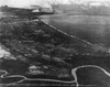
Location Nasugbu Airfield was located half a mile north of Nasugbu and half a mile east of the port of Wawa and Nasugbu Point. Prior to construction, the area was a sugar cane plantation. To the western edge of the airfield is Route 413. Construction Built prior to the war by the U.S. Army as an emergency landing ground (ELG). The airfield had two intersecting runways. The first NW/SE measuring 1,920' x 100' and the second NE/SW 1,350' x 66'. Both runways were grass surfaced and not usable in wet weather. Located at an elevation of 10' above sea level (ASL). Wartime History During January 1942, occupied by the Japanese Army. During the Japanese occupation of the Philippines, Nasugbu Airfield was reportedly repaired and expanded. On January 31, 1945 liberated by the U.S. Army 11th Airborne Division. Ki-43-III Oscar (Nasugbu No. 1) Force landed and captured January 31, 1945 Ki-43-III Oscar (Nasugbu No. 2) Destroyed on the ground at Nasugbu Airfield References Index to Air Bases - Research Report No. 85, I.G. No 9185 - July 30, 1944 - Nasugbu Airfield Terrain Study No. 95 Batangas-Lucena November 9, 1944, page 45 Thanks to Tony Feredo for additional information Contribute
Information Last Updated
|
Map 1944 |
| Discussion Forum | Daily Updates | Reviews | Museums | Interviews & Oral Histories |
|