|
|
|
|
| Missing In Action (MIA) | Prisoners Of War (POW) | Unexploded Ordnance (UXO) |
| Chronology | Locations | Aircraft | Ships | Submit Info | How You Can Help | Donate |
|
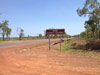 Daniel Leahy 2012  Daniel Leahy 2012 |
Location Hughes Field was located 30 miles south of Darwin and two miles south of Strauss Field (28 Mile), inland from the Stuart Highway in the Northern Territory (NT) of Australia. Also known as as "Hughes Airfield" or "30 Mile" or "28 Mile Drone" in reference to the distance from Darwin. To the north two miles away was Strauss Field (28 Mile). Wartime History Used by the Royal Australian Air Force (RAAF) during the Pacific War. Allied units based at Hughes 1 Photographic Reconnaissance Unit (F-4 Lightning) August 1942–December 6, 1942 departs Coomalie Creek 13 Squadron (Hudson) 1943 2 Squadron (Hudson/Mitchell) ? - August 14, 1945 Sepinggang During 1942–1943 bombed by Japanese aircraft. Japanese missions against Hughes August 23, 1942 Today Still in use today as an airfield for firebombing operations. Daniel Leahy adds: "I went to visit Hughes while in the NT on October 11, 2012, but it’s still used as for firebombing operations." CA-9 Wirraway A20-599 Destroyed by Japanese air raid on August 23, 1942 Buffalo A51-6 Destroyed by Japanese air raid on August 23, 1942 Hudson Serial Number A16-186 Pilot Mason crashed June 12, 1943 crashed 1 mile northeast of Hughes Field Contribute
Information Last Updated
|
Map 1943 Map March 1944 Photo Archive |
| Discussion Forum | Daily Updates | Reviews | Museums | Interviews & Oral Histories |
|