|
|
|
| Missing In Action (MIA) | Prisoners Of War (POW) | Unexploded Ordnance (UXO) |
| Chronology | Locations | Aircraft | Ships | Submit Info | How You Can Help | Donate |
|
 Davis October 3, 1945 |
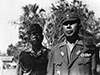
Location Lat 10° 10' 0S Long 123° 34' 60E Kupang is located at an elevation of 337' / 102m on the southwest of West Timor on Timor Island. Wartime spelling Koepang. Borders Kupang Bay (Koepang Bay). Prewar and during World War II part of Dutch Timor in the Netherlands East Indies (NEI). In 1949 after Indonesia independence, the western half became known as Indonesian Timor. Today located in West Timor (Timor Barat) in East Nusa Tenggara (Nusa Tenggara Timur) in Indonesia as the provincial capital and largest city. Wartime History On February 20, 1942 at 2:35am a Japanese Army landing force begins landing on each side of Cape Mali and secured the area without resistance by 3:15am. Afterwards, the Japanese "Kupang Force" proceeds over the mountains towards Kupang. Afterward, Australian Army commandos landed at Koepang to aid the Dutch and help defend Timor from the Japanese. Starting in the middle of May 1942 attacked by Allied aircraft until the end of the Pacific War. American missions against Koepang May 17, 1942–July 30, 1944 On October 3, 1945 in a surrender ceremony at Koepang, Imperial Japanese Army (IJA) Lt. General Kunitaro Yamada commander of the 48th Division surrendered the remaining Japanese forces in the Lesser Sunda Islands (Lesser Sundas) east of but not including Lombok Island to Australian Army is Australian Army Brigadier Lewis Glanville Howard Dyke, OBE, DSO, commander Timor Force. Koepang Airfield (Koepang Golf Course) Wartime airfield, today a golf course Koepang Seaplane Base Wartime seaplane base, today a golf course Koepang Cemetery Commonwealth War Cemetery References WW2 Nominal Roll - Lewis Glanville Howard Dyke, 331 (VX89) Contribute
Information Last Updated
|
Map Faillingrain |
| Discussion Forum | Daily Updates | Reviews | Museums | Interviews & Oral Histories |
|