|
|
|
| Missing In Action (MIA) | Prisoners Of War (POW) | Unexploded Ordnance (UXO) |
| Chronology | Locations | Aircraft | Ships | Submit Info | How You Can Help | Donate |
|
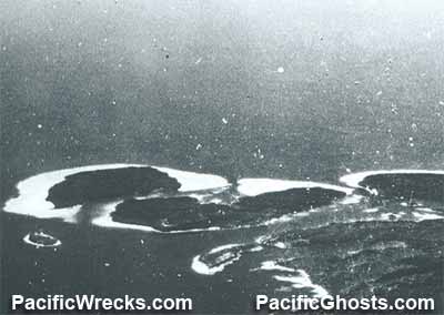 USN Oct 11, 1943  Justin Taylan 2005 |
Location Lat 7° 5' 60S Long 155° 49' 0E Magusaiai Island is located in the Shortland Island Group (Shortland Islands) in the northern Solomon Islands. Wartime spellings include "Morgusiai", "Morgusaia" or "Morgause". To the north is Shortland Island, to the east is Tuha Channel, Poporang Island and Alu Island (Pirumeri). Located to the south of Bougainville, at the western edge of Shortland Harbor (Tuha Channel) near Shortland Island and Poporang Island. Prewar and during the Pacific War part of the British Solomon Islands Protectorate (BSIP). Today part of Western Province in the Solomon Islands. Wartime History On March 30, 1942 occupied by the Japanese when they arrived in the Shortland Islands. Occupied by the Japanese until the official surrender of Japan in September 1945. American missions against Magusaiai September 6, 1943–January 6, 1944 Maleai (Malai) Located at the eastern tip of the Magusaiai Island. Contribute
Information Last Updated
|
Map Fallingrain |
| Discussion Forum | Daily Updates | Reviews | Museums | Interviews & Oral Histories |
|