|
|
|
| Missing In Action (MIA) | Prisoners Of War (POW) | Unexploded Ordnance (UXO) |
| Chronology | Locations | Aircraft | Ships | Submit Info | How You Can Help | Donate |
|
 U.S. Army Oct 1942 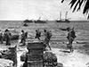 Australian Army Oct 1942 |
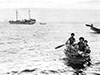
Location Lat 9° 19' 60S Long 149° 10' 0E Wanigela is located on the northern coast of New Guinea bordering Collingwood Bay near Cape Nelson and Dyke Ackland Bay to the south of Tufi. Also spelled "Waingela", "Waigela" or "Wanagilla". Also known as "Komabun" or "Kamabun". Wartime History During early July 1942 a small party of coastwatchers aboard HMAS Paluma charted the shipping channels from Waigela to Cape Nelson. During October 1942 Wanigela became vital to the Allies as a forward staging base for troops and equipment to support the campaign against the Japanese beachheads at Buna-Sanananda-Gona. From Wanigela, smalls ships would transport supplies and troops along the north coast of New Guinea to Pongani. During October 1942, a pier was built to facilitate the unloading of small ships and supplies. Wanigela was visited by Australian Army General Thomas Blamey and U.S. Army Brigadier General Hanford "Jack" MacNider, commander Buna Task Force. Waigela Mission Prewar an Anglican mission was established at Wanigela led by Reverend Dennis J. Taylor. After the Japanese landing at Gona in late July 1942, forty members of the mission evacuated by foot. Waigela Airfield Prewar Anglican mission at Waigela. B-25C "Pistoff" 41-12830 Pilot Lett ditched January 8, 1943 References HyperWar US Army in WWII - Victory in Papua pages 105-108, 109 (photos) 124 Contribute
Information Last Updated
|
Map 1943 Map Fallingrain Photo Archive |
| Discussion Forum | Daily Updates | Reviews | Museums | Interviews & Oral Histories |
|