|
|
|
| Missing In Action (MIA) | Prisoners Of War (POW) | Unexploded Ordnance (UXO) |
| Chronology | Locations | Aircraft | Ships | Submit Info | How You Can Help | Donate |
|
 Prewar  3rd BG February 28, 1943  90th BG August 10, 1943 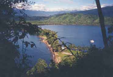 Ian Williams 1998  Richard Leahy 1996 |
Location Lat 7° 1' 60S Long 147° 4' 0E Salamaua is located on an isthmus on the north coast of New Guinea inside Huon Gulf. At the northern tip is Cape Parsee (Parsee Point) and Letu. Further down the isthmus is Salamaua (town) and MacDonald's Junction. Salamaua borders Salamaua Harbor (Samoa Harbor) to the north and Bayern Bay to the south. To the southwest on the mainland is Kela (Keila) and to the south is Nuk Nuk, Logui, mouth of the Francisco River and Salamaua Airfield (Logui Strip No 2) and L Point. Beyond to the north is Lae. Prewar located in the Morobe District in Territory of New Guinea. Today located in Salamaua Rural LLG, Morobe Province in Papua New Guinea (PNG). Prewar Salamaua town was developed as a hub for coastal shipping and to supporting gold mining operations inland at Wau. Buildings and facilities were constructed on the isthmus forming the town. Wartime History On January 21, 1942, Japanese aircraft attack Salamaua, including A6M2 Zeros from Shōkaku strafing the town and five Zeros flew inland to strafe Bulolo. The next day, the Australians evacuated the town, fearing further attacks. During early March 1942, Captain Allan Cameron arrived at Salamaua and was stationed at Salamaua Airfield. Japanese missions against Salamaua January 21, 1942 On March 8, 1942 before dawn, the Imperial Japanese Army (IJA) "South Seas Detachment" 144th Infantry Regiment landed at Salamaua. The few New Guinea Volunteer Rifles (NGVR) and civilian residents fled into the bush and began spying. Meanwhile, the Japanese developed the area into a base and anchorage. On March 10, 1942 U.S. Navy (USN) TBD-1 Devastator strike Japanese shipping off Salamaua, the first Allied air raid against Salamaua. For the next year and a half, Salamaua was targeted by Allied bombers and fighters until September 1943 when the Australian Army captured the area. American missions against Salamaua March 10, 1942–September 13, 1943 On June 28, 1942 a force of 450 Australian Army 2/5th Independent Company commandos under the command of Captain Norman Winning departs at 2:00pm to conduct a raid on Salamaua. Masked by rain that continued until midnight, the raid commenced on June 29, 1942 at 3:14am and continued for 45 minutes before the force withdrew. The Australians suffer only 3 wounded. They killed 120 Japanese and captured equipment and documents. Robert Manning adds: "Salamaua was the target of a raid by 75 Australian commandos on June 29, 1942 and another raid a few days later. There was intense interest by Allied intelligence in reconnaissance photos of the Salamaua peninsula from about the 28 June to about the first week in July 1942. I have yet to find any aerial photos of this period. The interest is over a house that sat high up of the seaward end of the peninsula above the tennis courts that can be seen in prewar photos. The house belonged to Mr O'Dea a prewar pilot and it was the target for a raid by several Australians." The Salamaua area was turned over to the Japanese Army on November 15. After the fall of Buna and Gona, the Allies began to attack Salamaua as a diversionary effort designed to divert enemy attention from the main Allied thrusts against Nadzab and Lae. By early September 1943, the Japanese were ordered to prepare to fall back as the Australian Army 5th Division apprached. A total of 5,000 personnel were evacuated by barge to Lae, an additional 600 escaped by submarine to Rabaul while 200 others walked overland to Lae. On September 11 , 1943 the Australian Army, 5 Division cross the Francisco River near Salamaua Airfield. On September 12 , 1943 Salamaua was liberated. Japanese Gun Emplacements & Tunnel Located on a hill top inland from Salamaua. A steep path leads up to four Japanese guns with commanding views of the harbor. Near the start of the path is an entrance to a Japanese tunnel. Type 3 (1914) 76.2 mm Naval Gun (No 1) Remains in situ Type 3 (1914) 76.2 mm Naval Gun (No 2) Remains in situ Type 3 (1914) 76.2 mm Naval Gun (No 3) Remains in situ, the barrel pointed at a horizontal angle Type 3 (1914) 76.2 mm Naval Gun (No 4) Salvaged by the Japanese in 1969, donated to Yasukuni Jinja B-17 pilot 2nd Lt George Munroe recalled: "I had an experience once, we were on a flight over Lae and Salamaua looking for a destroyer, reportedly up a creek. We knew there was no creek there, but were told to look at the area. We were flying along, fat dumb and happy and all of a sudden, all hell broke loose with anti-aircraft fire was all around us. We could see it we could hear it, I did a quick wing over and got out of there but we weren't touched." Coastwatcher's Ridge Location where Australian Coastwatcher was stationed to report Japanese shipping and troop movements. Mount Tambu A full days walk to Mount Tambu with spectacular views of the battlefield where Australians met the Japanese advance towards Wau. Also known as "Mt. Tambu". Local guides are available for those who want to make the trek. Yokohama Maru Sunk March 10, 1942 by USN carrier aircraft P-40E Kittyhawk Serial Number A29-38 Pilot Brown force landed April 11, 1942 wreckage sunk during 1980s failed salvage attempt Kotoku Maru (Kotoko Maru) Damaged by bombs and grounded off Salamaua July 30, 1942 DB-7B Mark III Boston A28-3 Tail DU-Y Pilot Newton ditched March 18, 1943 B-25D Mitchell 41-30313 Pilot Webster ditched July 9, 1943 References The Battle For Wau page 2 Hell's Battlefield page 24-26 Thanks to Phil Bradley and Robert Manning for additional information Contribute
Information Last Updated
|
Map 1942 Map 1943 Map Fallingrain Map Mapcarta Photo Archive |
| Discussion Forum | Daily Updates | Reviews | Museums | Interviews & Oral Histories |
|