|
|
|
| Missing In Action (MIA) | Prisoners Of War (POW) | Unexploded Ordnance (UXO) |
| Chronology | Locations | Aircraft | Ships | Submit Info | How You Can Help | Donate |
|
 Naomi Corpuz 2005 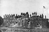 US Army 1898 |
Location Lat 14° 34' 0N Long 120° 58' 60E Located at the southern end of Manila. Borders Manila Bay to the west, Ermita to the northwest, Pasay to the south, and Paco and San Andres to the east. Binodo Church (Malate Church) Quintin Paredes Street Also known as Church of our Lady of the Rosary / Shrine of San Lorenzo Ruiz. faces a small park and beyond that Manila Bay in the Chinatown area. The church was built originally on this spot in the sixteenth century by the Augustinians, during the latter part of the 16th century to accommodate the Christian baptized Chinese and is one of the oldest churches in Manila outside of Intramuros. Noted for its six-story octagonal bell tower the shrine of the first canonized Filipino-Chinese martyr and saint, San Lorenzo Ruiz. British soldiers took refuge in this church during their occupation of the Philippines and attack on Intramuros in 1762-63. Destroyed in 1773, rebuilt. During World War II, the church was badly damaged and later restored again. Fort San Antonio Abad (Fuerte de San Antonio Abad) Located in the Malate district of Manila. Built by the Spanish began during 1584. The fort was triangular shaped with two bastions to guard Manila Bay, the rear approach to Intramuros and the road from Manila to Cavite. Named in honor of Saint Anthony the Abbott. Outfitted with cannons to guard Manila Bay and used as an alternative location for gunpower storage aside from the Polverin (Powder Magazine) near Bastion de San Diego at Intramuros posed. Wartime History During the Spanish American War, the fort was bombarded by US Navy ships during the Battle of Manila Bay, damaging the outer walls. On August 13, 1898 the American flag was raised when US Army forces of the 1st Colorado Regiment, 1st Batallion led by Lt. Col McCoy occupied the fort, becoming the first location in the Philippines occupied by American. During 1942-1945 Japanese forces occupied the fort and built a coment bunker inside and emplaced cannons. Damaged by bombing. Today Pigboat 39 page 17 mentions "Fort San Antonio" Contribute
Information Last Updated
|
Map Fallingrain |
| Discussion Forum | Daily Updates | Reviews | Museums | Interviews & Oral Histories |
|