| Josh Mcdade Reports from Bougainville | |||||||||
|


| Discussion Forum | Daily Updates | Reviews | Museums | Interviews & Oral Histories |
|
Josh Mcdade Reports from Bougainville
Typical river in Bougainville. Rocky beds which allows decent 4WD vehicles to cross. Many are knee deep and wide.
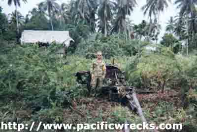
Josh McDade with Japanese AA gun at Harinai
On 28th of October 1999 Captain Thomson from Monitoring Team Tonu gave a number of OP BEL ISI members a small WWII history tour of the local area. He had spent quite a bit of personal time studying some aspects of local WWII history in Bougainville with help from friends and relatives in Australia and of course the internet.
Harinai is a small village with a proper public school. From Tonu head to Konga then go past Monoitu. Thanks to the principal of this school who gave his time to us to reduce our exploration time and gave us some very interesting 'stories'. We went to this village to visit a Japanese War Cemetery. On arrival the locals explained there was none at this location. We were not disappointed with the rest of our finds though.
The two major history experiences of the day was the visit to the village of Harinai and the exploration of Slater's Knoll. There were of course other great experiences of the day including but not limited to the company, interacting with the locals, discovering real pieces of history, the fantastic food, getting vehicles bogged repeatedly and finally crawling into bed for a rest. Many thanks to Capt Thomson and all the members of MT Tonu.
Photo of the Japanese anti-aircraft gun at Harinai lying on its side.Japanese 75mm Anti-Aircraft Gun
We were walked to a Japanese anti-aircraft gun. This gun is lying on its side and can be easily seen as seen in the photo. Pulling a few roots away from the metal gave some great shots of this piece of history still intact after all these years. I would say obviously visitors come from time to time and the are is cleared around it occaisionaly.The gun is in the centre of half a dozen huts. It is of course in someone's 'yard / garden'. So politeness and tact was in order. The lady of the house didn't seem upset that we came all this way to see a lump of metal that had been lying on the ground for over fifty years and walk around her 'yard/garden'. A story was shared with us that this particular gun had shot down four of the Allies aircraft throughout its working life time in this position. The story says that two of the craft that this gun shot down landed near this location. The following co-ordinates were supplied by Capt Thomson of the Australian army.
Tilted AA Gun at Harinai
GPS QT 6895 5800
This shot is of some of the aircraft wreck in the plantation at Harinai.
A CPL New Zealand medic is on the left and I on the right.
This shot is of some of the local school children, Jaquai (an Australian civilian peace moniter) and myself. We are amongst some of the aircraft wreckage that has been collected in this plantation and moved to the edge of it at Harinai.Harinai Aircraft Wreck
We were directed to a small local plantation within walking distance of the school. Trudging through this we were impressed upon finding aircraft wreckage, mainly the chassis and an engine. A real find of the exploration kind. The story goes that the Anti-Aircraft gun in Harinai shot down this plane.The Japanese came and located the wreckage and pilot. The pilot was Australian and found alive. The Japanese cut off his head and buried the body near what is now the school. The local story continues with the family coming to the area and exhuming the body. Unfortunately we could not obtain a definite year or even decade of this. Time in Bougainville is not quite the same as western time. A short walk could be 10 kilometers that takes six hours through jungle!
The wreckage of course has probably been moved many times due to the plantation crop rotation. More obvious damage has occurred to the wreck because of these moves. It appears to have hinged wings and tie down points. I am not a mechanic or plane expert of any type.
We all were unable to define what type of aircraft it was. The very damaged engine block seemed to be a dual V piston type. The following serials were found on different parts of the craft. A story goes that this area during the 'Crisis' was salvaged for weapon parts and ammunition.
The following co-ordinates were supplied by Capt Thomson of the Australian army.
Crashed aircraft at Harinai
GPS QT 6911 5722
69087D
502ll
8340 no2
Track to Slater's Knoll where we got bogged. The small re-entrant a few hundred meters below the knoll appears to have a bit of water in it at all times of the year. That's CPL Fox hitching up the rear vehicle to tow the forward vehicle out of the mud that it was up to its axles. We had to walk the rest of the way up the hill and then ensure that we were in the correct area.Slater's Hill
We drove to Slater's Hill as described in Chapter 7 of the Official War Histories VII written by Gavin Long. This and many other texts can be found at the Australian War Memorial (Chapter 7 in Official Australian War Histories by Gavin Long).
Still a few hundred meters away in a small valley we bogged the vehicle twice and had to winch the vehicles out. We then set out up the hill on foot leaving a piquet on the vehicles.After getting his bearings and ensuring that we were on the correct hill Capt Thomson gave an oral history. He read some of the history to the group of the preceding days and the battle that resulted in the naming of the hill. Whilst reading the history we were able to look around us to find the reference points mentioned and imagine ourselves being bombarded over fifty years ago.
Words can not explain the feeling of being a serving soldier on operations in an area that soldiers before had battled over. We moved off the track and into the vegetation. Within about fifty meters we found evidence of the dug in positions that were here.
We moved about the depressions looking for any other tell tale signs. The obvious one was the reduced amount of lower vegetation compared to other places. It was quite obvious that at some time the local flora had been obliterated. The trees were thin and and like vines with little to no undergrowth.
Unfortunately time had got away from us and dusk was approaching. We only had a few minutes to investigate the numerous large sunken depressions. Also Unfortunately all the photos taken were too dark and didn't come out. What a fantastic day and thanks to many people too numerous to list.
The following co-ordinates were supplied by Capt Thomson of the Australian Army. Slaters Knoll QT 564 673
Return to Josh Mcdade
Discussion Forum Daily Updates Reviews Museums Interviews & Oral Histories
Pacific Wrecks Inc. All rights reserved.