|
|
|
|
| Missing In Action (MIA) | Prisoners Of War (POW) | Unexploded Ordnance (UXO) |
| Chronology | Locations | Aircraft | Ships | Submit Info | How You Can Help | Donate |
|
  USN Nov 20, 1942 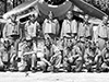 USN Nov 20, 1942 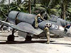 USMC c1943  USMC September 1943 |
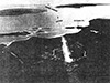
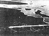
Location Turtle Bay Airfield was located on the eastern coast of Espiritu Santo (Santo). Also known as Turtle Bay Field or Fighter 1. To the north is the Nalaiafu River and to the northeast is Turtle Bay. To the east is the Vaucluse Passage, Matte Vulu Island and Mavia Island (Mafia). To the southeast is Peterson Point, Aesi Island (Aessi Island) and further to the south is Lungaville (Santo). Prewar and during the Pacific War located in New Hebrides. Today located in Sanma Province in Vanuatu. Prewar This area was plantation with coconut palms harvesting copra. Construction By late 1942, a single runway was built at this location with a taxiways and revetments off both sides of the runway. Turtle Bay Airfield was built by a detachment from 3rd Naval Construction Battalion (3rd NCB) "Seabees" augmented by labor from A Company, 24th Infantry Regiment (Colored). Wartime History During the Pacific War, used by American fighter aircraft including U. S, Marine Corps (USMC) squadrons. American units based at Turtle Bay Airfield (Fighter 1) VMF-213 (F4U) March 1943 - April 1943 Guadalcanal VMF-214 (F4U) March 1 - 14, 1943 Guadalcanal VF-33 (F6F) ? - ? Guadalcanal Today Disused since the Pacific War and overgrown. Contribute
Information Last Updated
|
Map 1942 Map 1997 View in Google Earth Photo Archive |
| Discussion Forum | Daily Updates | Reviews | Museums | Interviews & Oral Histories |
|