|
|
|
|
| Missing In Action (MIA) | Prisoners Of War (POW) | Unexploded Ordnance (UXO) |
| Chronology | Locations | Aircraft | Ships | Submit Info | How You Can Help | Donate |
|
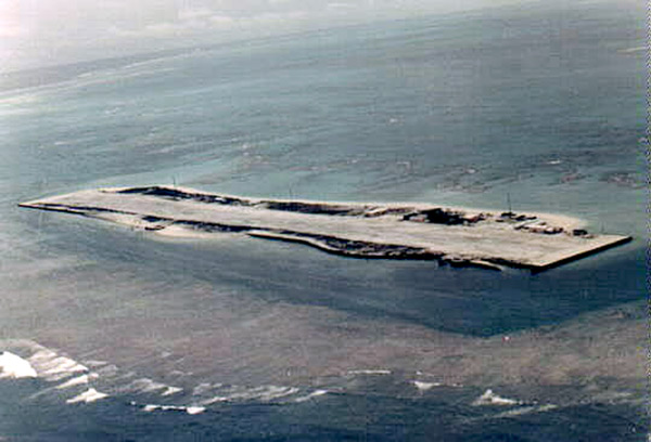 1966 Jim Haralson |
Location Lat 23° 51' 50N Long 166° 17' 5W Tern Island Airfield is located at an elevation of 6' above sea level spanning Tern Island at the northern end of the French Frigate Shoals in the Northwestern Hawaiian Islands (Leeward Islands) of Hawaii in the United States. Still in use today as French Frigate Shoals Airport. Construction During early 1943, built by U.S. Navy (USN) Naval Construction Battalion (NCB) "Seabees" enlarged Tern Island by dredging coral to use as fill to build a single runway 3,300' x 400' that surfaced with crushed coral with a ramp area. Before completed, the only link to the French Frigate Shoals was by seaplane or boat. Wartime History On March 15, 1943 designated as Naval Auxiliary Air Facility French Frigate Shoals (NAAF French Frigate Shoals) was established at this location. Before the runway was completed, the only link to the French Frigate Shoals was by seaplane or ship. During 1943 until the end of the Pacific War, used by U.S. planes flying daily reconnaissance missions. could accommodate up to 24 single engine aircraft. Also used as an emergency landing strip. Postwar On April 1, 1946 the Aleutian Islands earthquake created a tsunami that washed over Tern Island. Damaged, the Navy closed the naval air facility. During 1952, the U.S. Coast Guard (USCG) built a Long Range Navigation (LORAN) tower and facility on the island for a contingent of 20 personnel. The runway was used to support them with weekly flights to and from Hawaii to deliver supplies and mail until closed in 1979. The runway was also used by commerical flights to support fishing fleets. Today Still in use today as French Frigate Shoals Airport as a small airport. The single runway is oriented 26/06 measures 3,000' x 200' surfaced with coral. Airport code: ICAO: PHHF, FAA: HFS. Today, owned by the U.S. Fish & Wildlife Service for flights to the Hawaiian Islands National Wildlife Refuge. References The Coral Carrier French Frigate Shoals, Northwestern Hawaiian Islands: A History (2012) by A. Binion Amerson Contribute
Information Last Updated
|
Map January 1945 Map Fallingrain View in Google Earth |
| Discussion Forum | Daily Updates | Reviews | Museums | Interviews & Oral Histories |
|