|
|
|
|
| Missing In Action (MIA) | Prisoners Of War (POW) | Unexploded Ordnance (UXO) |
| Chronology | Locations | Aircraft | Ships | Submit Info | How You Can Help | Donate |
|
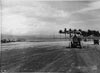 Australian Army August 2, 1945  Brian Bennett 1988 |
Location Lat 4° 58' 51S Long 152° 0' 36E Tol Airfield is located at an elevation of 49' above sea level at Tol inland from Zungen Point, to the east is Henry Reid Harbor and Henry Reid Harbor Seaplane Base and further west Wide Bay. Prewar, this area was Tol Plantation planted with coconut palms harvesting copra. Today located in East New Britain Province in Papua New Guinea (PNG). Construction During early August 1945, Tol Airfield was built by the Australian Army 2/3 Railway Construction Company. Today Single grass runway running roughly east to west. Airport code IATA: TLO. Disused in recent years, but still serviceable. Tol Massacre Memorial Located on the western edge of Tol Airfield. A stone monument with a memorial plaque was dedicated May 1987. Contribute
Information Last Updated
|
Map Fallingrain View in Google Earth |
| Discussion Forum | Daily Updates | Reviews | Museums | Interviews & Oral Histories |
|