|
|
|
|
| Missing In Action (MIA) | Prisoners Of War (POW) | Unexploded Ordnance (UXO) |
| Chronology | Locations | Aircraft | Ships | Submit Info | How You Can Help | Donate |
|
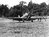 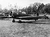 RAAF December 1942 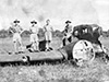 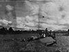 Watson December 1942 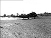 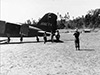 Watson December 28, 1942 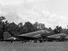 163rd Regiment c1943 |
Location Popondetta Airfield was located to the west of Popondetta in New Guinea. The Kokoda-Buna Road (Kokoda Highway) is parallel to the western side of the runway and loops around the southern end then continues eastward to Popondetta. To the west is Sangara and beyond to the south is Mount Lamington. Prewar and during the Pacific War located in Northern District (Northern Province) in the Territory of Papua. Today located Popondetta Urban LLG in Ijivitari District in Oro Province in Papua New Guinea (PNG). Construction Prior to development, this area had kunai grass and was wide and flat making it a natural landing ground. Built by the U.S. Army along with Doboudra Airfield as one of the first landing grounds constructed on the north coast of New Guinea to support Allied operations during the Buna-Gona-Sanananda campaign. The single runway was grass surfaced oriented roughly north to south. After the Buna-Gona-Sanananda campaign, expanded with a pair of parallel runways. Wartime History During the battle of Buna-Gona-Sanananda, Popondetta Airfield was used by Allied aircraft flying from Port Moresby to Popondetta Airfield to transport cargo and personnel to the battlefield area or for battlefield reconnaissance. Fuel drums were stockpiled at the airfield to support flight operations. During December 1942, Popondetta Airfield was at the height of operation and used by by U.S. Army Air Force (USAAF) C-47 Skytrains and to a limited degree by the Royal Australian Air Force (RAAF) flying from Port Moresby. At least one Wirraway from No. 4 Squadron was photographed parked at Popondetta Airfield. On December 3, 1942 while landing, C-47 "Johnny Reb" 41-18571 crashed and burned due to pilot error without casualties at or near Popondetta Airfield. The wreckage of at least one C-47 Skytrain was abandoned at Popondetta Airfield and stripped for usable parts then abandoned. On December 4, 1942 during take off from Popondetta Airfield, Wirraway A20-551 pilot F/O I. C. Curtis hit a large rock in the grass and the plane was damaged beyond repair with the crew unhurt. On December 28, 1942 at least two C-47 Skytrains were photographed parked at Popondetta Airfield: C-47 "Shamrock" 41-18586 and C-47 "Flamingo" 41-18584 to transport Australian Army 2/4th Field Ambulance personnel back to Port Moresby. During early January 1943 the Australian Army 36th Battalion was flown from 5 Mile Drome (Ward) to Popondetta Airfield then marched to the north coast to enter combat at Sanananda. After the battle, flight operations switched to Dobodura area airfields. C-47 Skytrain Crash landed at Popondetta Airfield as of December 1942. C-47 "Johnny Reb" 41-18571 Crashed December 3, 1942 due to pilot error likely at or near Popondetta Airfield. CA-9 Wirraway A20-551 Pilot Curtis damaged on take off December 3, 1942 C-47 "Junior" Pilot 2nd Lt. Harry D. Dingman crashed July 11, 1943 half mile from Popondetta Airfield. Postwar Possibly, used as a landing ground. Likely, covered in ash between January 18-21, 1951 during the eruption of Mount Lamington that triggered a pyroclastic flow devastating a 14km radius. Although disused, Popondetta Airfield remained listed on Australian Army topographic and survey maps until at least the late 1970s. Today Disused and overgrown with kunai grass. At the center of the former runway is a disused timber sawmill that is fenced off and used for storage. References Field Guide to the Kokoda Track by Bill James (2006) pages 395 (map), 410, 412 (map) Allied Air Transport Operations South West Pacific Area in WWII, Volume Two (2006) pages 11 (July 11, 1943 crash casualties), 13 (54th TCW losses July 11, 1943), 58 (July 11, 1943 crashed into the jungle a half mile from Popondetta), 71-72 (July 11, 1943 C-47 41-38663), 120 (317th TCG missions to Popondetta), 188 (Popondetta Airfield during Buna-Sanananda campaign), 559 (index Popondetta) Thanks to Paul Roales and Edward Rogers for additional research and analysis Contribute
Information Last Updated
|
Map TOC N-15A Map 1971 Map Fallingrain Map Mapcarta Photo Archive |
| Discussion Forum | Daily Updates | Reviews | Museums | Interviews & Oral Histories |
|