|
|
|
|
| Missing In Action (MIA) | Prisoners Of War (POW) | Unexploded Ordnance (UXO) |
| Chronology | Locations | Aircraft | Ships | Submit Info | How You Can Help | Donate |
|
 USAAF November 1942 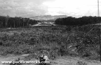 USAAF December 1942 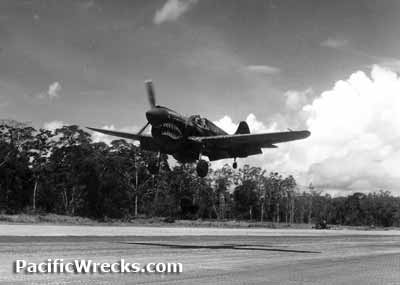 USAAF c1943 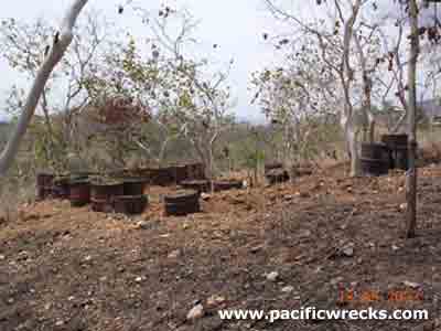 M Claringbould 2004 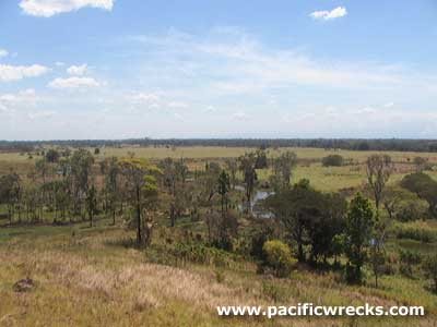 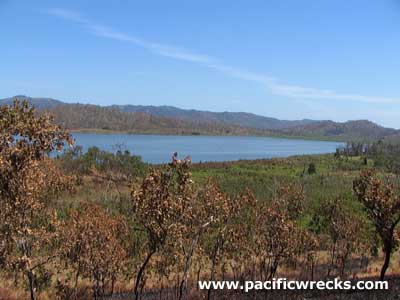 Justin Taylan 2004 |
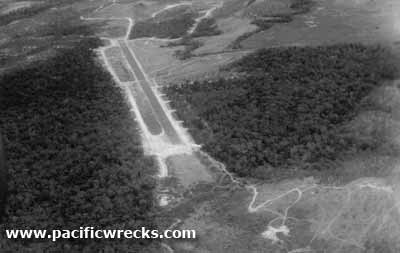
Location Lat 09°22′57.35″S Long 147°10′23.76″E 17 Mile Drome was located roughly 17 miles north of Port Moresby inland from the southern coast of New Guinea. To the south is Waigani Swamp and to the southeast is 14 Mile Drome (Schwimmer, Laloki) and to the southwest is Gerehu. Before 1942, this area was undeveloped and covered with kunai grass and swamp. Construction During August 1942, the U.S. Army 808th Aviation Engineering Battalion (808th Engineer Airborne Battalion, 808th EAB, 808th Engineers) commanded by Captain Andrew D. Chaffin, Jr. O-20153 (West Point Class of 1936). Over the next three weeks, the engineers began constructing an airfield at this location. Construction began on a single runway running roughly northwest to southeast. Afterwards, Chaffin earned the Purple Heart “For a singularly meritorious act of essential service at Durand Field, New Guinea, during August 1942". From a jungle swamp, unfit for foot travel or for habitation, Major Chaffin, in a period of approximately three weeks, constructed and rendered fit for aircraft operational use Durand Field. The actions of this officer have thereby set an example of courage and leadership which are worthy of the highest commendation". To the southeast of the runway, dispersal and camp areas were built, where revetments carved into hillsides and taxiways elevated for proper drainage. Gun pits built around empty 55 gallon drums filled with soil were made for anti-aircraft guns and on the surrounding hills, and concrete slabs poured for the foundation of buildings and tents. Gravel from the nearby quarry was used for surfacing the runway and taxiways. During early September when Japanese forces were within 28 miles of Port Moresby, the 808th was ordered to cease work and take up positions as combat reserves along the Goldie River until the arrival of reinforcements. On October 21, 1942 torrential rains, ahead of the "wet season" washed out the shale base of the runway at 7 Mile Drome and several nearby roads and bridges. The rain damaged was not repaired until later in the month. During this period, two thirds of the 808th Engineer Airborne Battalion worked to expand 17 Mile Drome to accommodate B-17 Flying Fortresses. Wartime History During late 1942, the airfield went into service for use by fighters and medium bombers during all of 1943, known as "17 Mile Drome" or "17 Mile" or "Waigani" or "Waigani Field". On November 10, 1942 officially renamed "Durand Drome" to honor of P-39F Airacobra 41-7128 pilot 1st Lt. Edward D. Durand Missing In Action (MIA) April 30, 1942. By early 1944, the American units moved northward to Dobodura and Nadzab. During 1944, a RAAF Repair & Salvage Unit (RSU) operated at the airfield. Allied units based at 17 Mile (Durand) U.S. Army Air Force (USAAF) 3rd BG, 13th BS (B-25) arrives October 7, 1942 3rd BG, 90th BS (B-25) ? 38th BG, 71st BS (B-25) Breddan arrives October 1, 1942–March 5, 1944 departs Nadzab 38th BG,, 822nd BS (B-25) Australia arrives June 20, 1943–March 8, 1944 departs Nadzab 38th BG, 823rd BS (B-25) Australia arrives June 20, 1943–March 7, 1944 departs Nadzab 38th BG, 405th BS (B-25) Garbutt / 14 Mile Drome arrives October 25, 1942–March 6, 1944 departs Nadzab 49th FG, 7th FS (P-40) ?–Dobodura 475th FG, 432nd FS (P-38) Amberley arrives August 12, 1943–September 1, 1943 departs Dobodura No. 15 345th BG, 499th BS (B-25) ?–January 15, 1944 departs Dobodura 345th BG, 500th BS (B-25) ?–January 1, 1944 departs Dobodura Royal Australian Air Force (RAAF) RSU (Repair & Salvage Unit) William Smith, 38th Bombardment Group, 71st Bombardment Squadron recalls: "Dense jungle surrounded this Port Moresby strip [17 Mile Drome]. One time a crew bailed out only three miles from the base, but it took them a week to get back!" Gurden Barnett, 38th Bombardment Group, 405th Bombardment Squadron recalls: "We were afraid to swim in the swamp nearby, because one night some of the guys found and killed a snake. In the morning, it proved to be 26 feet long! Occasionally the Japanese would bomb us, mostly harassment raids of one or a few Japanese planes. After the Americans moved northward to Dobodura and Nadzab, Durand was turned over to the Australians and based a Repair & Salvage Unit (RSU). Postwar During the 1960-1970 known as Durand Farm and used as a cattle ranch with barbed wire fences strung around the property. Possibly, a single brick building was established at the farm and lived at this location. Today Abandoned by the 1980s, Durand has remained relatively isolated and disused since the war. There are no permanent settlements in the area aside from a few squatters, only occasionally do people pass through the area searching for firewood or hunting. The former taxiways were occasionally used by rally cars for sprints, until a final race in 1987. In the 1990s, the National Housing Corporation (NHC) and National Housing Estates Ltd., a public-private venture announced plans to house their employees in this area. In 1993, a single bulldozer that came in on the existing road and over several hillsides, presumably marking boundaries. The runway, revetments and taxiway system are still present, but only clearly visible in the dry season when the grass has been burned away. In 2014, plans were again announced by the National Housing Corporation (NHC) to build 40,000 new homes for public servants at two sites: Durand and behind the National Research Institute (NRI) at Gerehu. Henry Mayer adds: "Since 1980, I have made several trips down to the other end of the airstrip which seems to have had only a few campsites, but a lot of dugouts going all the way up to the highest point. Apart from the Australian tag belonging to Floyd Hammond of the 86th ordinance battalion and a pair of aircraft manifolds lying on the lower part of the hill the place was quite bare and seemed to have been used for a short time only. Between the two jungle patches at the runways end is the small stream which actually drains the lake and has a road crossing it. The crossing is still there but was on the point of collapse when i visited in 95 with just enough width (30cm) remaining in the middle to ride my bike across. The road continues around the hills along to the main road at Gerehu (Wallaby ordinance dump then) suburb and still has dirt ordnance bays laid out neatly alongside it, not to mention the burnt out remains of a few stolen vehicles stippled and abandoned. I also checked out the middle section of the runway which in the shot shows a straight road/taxiway leading off at 90 degree on the right. In this area there are concrete foundations hidden among raintrees and further out in thick kunai i found quite a few metal scraps, drums, aircraft manifolds and a section with two metal gun box data plates attached for P-40E Warhawk." B-25D "Blunder Bus" 41-30028 Crashed July 8, 1943 after take off. Wreckage likely scrapped in the 1980s References Radio New Zealand International "40,000 government houses to be built in PNG capital" February 25, 2014 Engineer Aviation Units in the Southwest Pacific Theater during WWII by Natalie M. Pearson, 2005 [PDF] pages 39, 42, 44, 46 Thanks to Henry Mayer for additional information Contribute
Information Last Updated
|
Map Oct 7, 1942 Map 1942 Map Aug 31, 1943 View in Google Earth Photo Archive |
| Discussion Forum | Daily Updates | Reviews | Museums | Interviews & Oral Histories |
|